Section 3.5 Wildlife and Ecosystem Services Working Group
|
|
|||||||||
3.5.1 Introduction
The availability and quality of both wildlife habitat and ecosystem services are entirely dependent on ecosystem form and function, and as such the work to be done by the four core projects that comprise the Wildlife and Ecosystem working group overlaps significantly with that of working groups focused explicitly on vegetation, hydrology, fire disturbance and permafrost. Sections II-IV summarize the field (II), remote sensing (III) and modeling (IV) activities that are specific to the Wildlife and Ecosystem working groups. Each of these sections includes summaries of: our own activities; needs, coordination & synergies we have with other working groups; and critical data and/or knowledge gaps (if any) that we have identified to date. Section V summarizes stakeholder engagement activities, emerging Science Team – stakeholder collaborative opportunities, and important comments and suggestions made by stakeholder groups that are particularly relevant to the Wildlife and Ecosystems group.
Overarching objectives: We have the following two overarching objectives. First, we seek to understand how spatial and temporal dynamics in environmental and ecological conditions within the ABoVE Study Domain influence:
(a) movement, habitat selection and population viability of a suite of highly mobile terrestrial animal species; (b) accessibility of subsistence resources to local communities; and (c) resilience and vulnerability of coastal terrestrial
habitats. Second, we seek to engage local stakeholders—including natural resource agencies, wildlife managers, First Nations, native Alaskans, and other stakeholders—and provide them with knowledge, products, and tools
that will aid them in making informed management and adaptation decisions,
3.5.2 Field Research
Overview: Each of the four core studies represented in this working group is planning a multi-annual field campaign. The field data that will be collected falls into seven broad categories: 1) animal location and body condition, 2) vegetation cover, 3) soil, hydrology, and permafrost properties, 4) snow properties, 5) meteorological data, 6) documentation of traditional ecological knowledge, and, 7) mapping of subsistence travel networks and disturbance events that inhibit travel. A comprehensive list of the field variables we will collect is provided in Table 1. Our field studies differ in their respective spatial extents and geographical locations within the ABoVE Study Domain so that overall, there is little spatial overlap among each studies’ suite of field observations (Figure 1).
Needs, coordination & synergies with other WG projects:
There is at least one project in another working group that will collect field datasets that would augment and complement our own by increasing sample
sizes and/or extending geographic and/or temporal coverage as follows. Specifically, Kevin Schaefer’s group is measuring active-layer thickness in burned and unburned upland tundra in the 2015 Kuka Creek tundra wildfire
complex in August 2016; these measurements are of interest to the regional-scale remote sensing component of Frost’s YK Delta project.
| Project PI | Field variable | Location | Timing |
| Boelman | American Robin GPS locations | Robin travel paths (tagged at Great Slave Lake, NWT) | April 2016-2018 |
| Brown Bear GPS locations | Tok area, Denali NP, AK | 2008-present | |
| Caribou GPS locations | Central and northeastern Alaska; NWT | 1995-present | |
| Golden eagle GPS locations | Central AK and eastward, domain-wide | 1997-2019 | |
| Moose GPS locations | Central AK, Brooks Range | 2005-2018 | |
| Wolf GPS locations | Lake Clark, Yukon-Charley, Denali, Nelchina AK | 2000-present | |
| Prugh | Dall Sheep GPS & VHF locations | Brooks Range, Alaska Range, Wrangells, Richardsons | 1997-2018 |
| Dall sheep survey & harvest data | Alpine areas domain-wide | 1970's - present | |
| Dall sheep physiological measurements | Wrangell St-Elias National Park, alpine zone | 2017-2018 | |
| Peak snow depth | Wrangell St-Elias National Park, alpine zone | 2017-2018 | |
| Snow water equivalent | Wrangell St-Elias National Park, alpine zone | 2017-2018 | |
| Snowpack stratigraphy | Wrangell St-Elias National Park, alpine zone | 2017-2018 | |
| Hourly snow depth & temperature | Wrangell St-Elias National Park, alpine zone | 2017-2018 | |
| Daily climate data | Chisana and May Cr SNOTEL stations, Wrangells | 2017-2018 | |
| Brinkman | Subsistence harvester travel routes | Yukon River watershed, Alaska | 2016-2017 |
| Structured surveys of harvesters | Yukon River watershed, Alaska | 2016-2017 | |
| Disturbance site characteristics | Yukon River watershed, Alaska | 2016-2017 | |
| Frost | Vegetation species-cover (point-intercept) | Yukon-Kuskokwim Delta, Alaska | 2016-2017 |
| Surface elevation (m) | Yukon-Kuskokwim Delta, Alaska | 2016-2017 | |
| Water depth (cm) | Yukon-Kuskokwim Delta, Alaska | 2016-2017 | |
| Soil pH | Yukon-Kuskokwim Delta, Alaska | 2016-2017 | |
| Soil electrical conductivity | Yukon-Kuskokwim Delta, Alaska | 2016-2017 | |
| Soil organic depth (cm) | Yukon-Kuskokwim Delta, Alaska | 2016-2017 | |
| Soil stratigraphy | Yukon-Kuskokwim Delta, Alaska | 2016-2017 | |
| Depth to seasonally saturated soil (cm) | Yukon-Kuskokwim Delta, Alaska | 2016-2017 | |
| Thaw depth (cm) | Yukon-Kuskokwim Delta, Alaska | 2016-2017 | |
| Ecotype class (Jorgenson et al. 2000) | Yukon-Kuskokwim Delta, Alaska | 2016-2017 | |
| Geomorphic unit (Jorgenson et al. 2000) | Yukon-Kuskokwim Delta, Alaska | 2016-2017 | |
| Surface form class (Jorgenson et al. 2000) | Yukon-Kuskokwim Delta, Alaska | 2016-2017 | |
| Indiginous knowledge from community meetings | Y-K Delta | 2016-2018 |
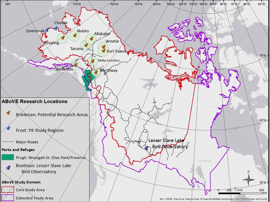
Figure 1. This map will be periodically updated as coordinates and site selection are refined.
Data and knowledge gaps
Salmon is an important source of nutrition for many of the local subsistence communities, and in fact is the primary food source for communities in the Yukon River watershed where the
Brinkman project will be working. Similarly, several wildlife species depend on salmon as a major source of food (e.g. bears and raptors). As the Arctic warms, the spatial and temporal characteristics of salmon habitat are changing
with shifts in seasonality of river freeze/thaw status, as well as shifts in seasonality and magnitude of flow rates. These changes will affect the size and timing of salmon runs in largely unexplored ways, thus altering availability
of this critical food source to local subsistence communities and wildlife. However, the ABoVE Science Team does not have data on salmon runs, and for the reasons described, we see this as a critical data gap. For this reason,
we seek past and ongoing annual time series data on the seasonal timing and abundance of any of the major salmon runs occurring in the ABoVE Study domain (for Boelman project), especially those occurring within the Yukon River
watershed (for Brinkman project). Currently, we are considering asking both local subsistence communities and government agencies for salmon census data they may have collected/be collecting in the ABoVE Study Domain as an
alternate and/or additional approach to acquiring field survey data on salmon runs, we will use modeled data on habitat vulnerability rankings for the major salmonid stocks in Alaska (from Riverscape Analysis Project)
Overview: Remotely sensed data (and their derivative geospatial products) are central to all of the projects that make up the Wildlife and Ecosystems Services group, and represent a common thread throughout the entire ABoVE project. Specific remote sensing research in the Ecosystems and Wildlife Services group will focus on efforts to characterize spatial and temporal dynamics in a large suite of ecosystem properties, including those associated with vegetation, hydrology, permafrost, meteorology, and disturbances (e.g., wildfire). Subsistence communities establish large travel networks for hunting, fishing, and gathering, and highly mobile wildlife species travel even larger areas annually. In order to survive/thrive, both adjust their locations and movements in temporal and spatial accordance with the highly dynamic nature of environmental and ecological conditions that typify Arctic and boreal regions. As such, localized field approaches alone will not advance broad understanding of how subsistence communities nor highly mobile wildlife species are affected by environmental or ecological extremes. In contrast, remotely sensed data and derived products provide the geographical and temporal coverage that is required for modeling work (discussed in more detail below) that will elucidate the relationships between environmental/ecological dynamics and both subsistence resource availability and animal behavior. The space- and air-borne remote sensing research to be conducted by the Wildlife and Ecosystems Services group will be broad in scope and is summarized in Table 2. Additionally, there is significant overlap and synergistic opportunities between the remote sensing research to be done by our group and other working group themes (see Table 3), as well gaps in remote sensing data maturity or availability that have been identified as critical to achieving the objectives of the Wildlife and Ecosystems Services group.
Table 2. Summary of space- and air-borne remote sensing data or products that the Wildlife and Ecosystems group is currently planning to use.| Common remote sensing data and products | Location(s) | Project(s) |
| Satellite - High res passive data/products from PGC/NGA | Domain-wide/site-specific | Boelman, Prugh (alpine), Brinkman (Yukon R), Frost (Y-K Delta) |
| Satellite – Landsat and other passive data/products with ca. 30m resolution | Domain-wide/site-specific | Boelman, Prugh (alpine), Brinkman (Yukon R), Frost (Y-K Delta) |
| Satellite – MODIS and other passive data/products with ca. 250-1000m resolution | Domain-wide/site-specific | Boelman, Prugh (alpine), Brinkman (Yukon R), Frost (Y-K Delta) |
| Satellite - ASTER GDEM | Domain-wide/site-specific | Boelman, Prugh (alpine), Brinkman (Yukon R), Frost (Y-K Delta) |
| Satellite - NOAA's Global Precipitation Measurement (GPM) | Domain-wide/site-specific | Boelman, Prugh (alpine) |
| Satellite - SMMR, SSM/I, SSMIS for ‘MEaSUREs‘ product (Kim et al. 2012) | Domain-wide/site-specific | Boelman, Frost (Y-K Delta, SSM/I) |
| Satellite - NOAA Soumi NPP | Domain-wide | Boelman |
| Satellite - AVHRR | Y-K Delta | Frost |
| Airborne – G-LiHT (Hyperspectral, LiDAR, Thermal imaging package) - 350m wide swath, long flightlines | Core sites and/or site-specific | Boelman, Brinkman (Yukon R) |
| Airborne – Historical Aerial Photos | Core sites and/or site-specific | Prugh, Brinkman, Frost |
| Airborne - L-Band InSAR | Core sites and/or site-specific | Boelman |
| Airborne – LiDAR (non-G-LiHT) | Core sites and/or site-specific | Boelman |
| Airborne – UAV video | Core sites and/or site-specific | Brinkman |
Needs, coordination & synergies with other WG projects
There are several projects in other working groups that will use remotely sensed datasets (or derived products) that are either the same or similar to
our own remotely sensed data needs. Importantly, there are also several datasets that will be developed by other working group projects that will complement and add to our work in very valuable ways. Although the majority
of this overlap and complementarity is in vegetation specific datasets, several hydrologic and disturbance related datasets are also included. Table 3 outlines each of these datasets.
| WG theme | RS type | RS dataset/product | Application | Location | PI(s) producing desired dataset/product | WES PI(s) desiring dataset/product |
| Vegetation | Satellite | Lichen cover maps | Caribou winter forage assessment | Alaska Interior and North Slope | Goetz | Boelman |
| Satellite | NDVI trend maps | Animal habitat selection; vegetation dynamics | Domain-wide; alpine areas | Goulden, Woodcock, Cook, Ranson, Gamon, Prugh | Boelman, Frost, Prugh | |
| Satellite | Disturbance history maps | Animal habitat selection; vegetation dynamics and disturbance regime; accessibility of subsistence resources | Domain-wide; Yukon River watershed | Woodcock | Boelman, Brinkman, Frost | |
| Satellite/airborne | Shrub cover maps | Vegetation dynamics and disturbance regime; accessibility of subsistence resources | Yukon River watershed; YK Delta; alpine areas | Brinkman, Chopping, Eitel, Frost, Goetz, Prugh, Ranson | Boelman, Brinkman, Frost, Prugh | |
| Satellite/airborne | 3-D vegetation structure maps | Ecosystem mapping; vegetation dynamics and disturbance regime; accessibility of subsistence resources | Domain-wide | Boelman, Chopping, Eitel, Frost, Goetz, Vierling, | Boelman, Brinkman, Frost, Prugh | |
| Fire & disturbance | Satellite | Wildfire history maps | Animal habitat selection; vegetation dynamics and disturbance regime; accessibility of subsistence resources | Domain-wide; Yukon River watershed | Loboda | Boelman, Brinkman, Frost |
| Airborne | Insect outbreak history maps | Animal habitat selection | Domain-wide | Cook | Boelman | |
| Hydrology & permafrost | Satellite | Surface water extent maps | Animal habitat selection; surface water dynamics; accessibility of subsistence resources | Domain-wide | Carroll | Boelman, Brinkman, Frost |
| Active-layer thickness maps | Vegetation dynamics, disturbance regime | YK Delta | Schaefer | Frost | ||
| Lake- and river-ice thickness | Accessibility of subsistence resources | Yukon River watershed | NONE THUS FAR | Brinkman | ||
| Snow and ice cover maps | Animal habitat selection; accessibility of subsistence resources | Domain-wide; alpine areas; Yukon River watershed | Prugh (alpine); [aren't there others too?] | Boelman, Brinkman, Prugh | ||
| Snow depth and icing events | Animal habitat selection; Accessibility of subsistence resources | Domain-wide; alpine areas | Kimball (domain-wide), Prugh (Wrangells) | Boelman, Brinkman, Prugh | ||
| Thermokarsting | Assessibility of subsistence resources | Yukon River watershed |
Data and knowledge gaps: The following describes three major thematic gaps in remote sensing product maturity and/or suitability that have been identified below as critical to achieving the objectives of the Wildlife and Ecosystems Services group.
- Snow properties other than cover extent: Although datasets used to derive snow cover dynamics products are available and suitable to the majority of our studies, datasets suitable for assessing dynamics
in other snow properties that are important to understanding wildlife behavior/health and availability/accessibility of ecosystem services are inadequate in their spatial and/or temporal resolutions, and/or are challenging
to retrieve from satellite sensors. The two most critical of these missing datasets are:
- the occurrence of icing events which reduce mobility and access to forage and have caused recent catastrophic die-offs in northern ungulate populations (Putkonen et al. 2009, Rennert et al. 2009, Stien et al. 2010, Hansen et al. 2011, Hansen et al. 2014). Current satellite passive microwave sensors including SSM/I and AMSR provide higher frequency (K-band) retrievals of daily surface freeze thaw status that can be combined with other satellite based retrievals of snowcover extent (e.g. MODIS snow product) to identify snow cover wetting and refreezing events (Kim et al. 2015) that may be linked to snow icing events and associated changes in snow structure. However, these data are limited to relatively coarse (6-25 km resolution) spatial scales that may be too coarse for many wildlife applications including animal habitat selection and movement patterns, especially in complex mountain landscapes. Conversely, while finer scale freeze-thaw data is potentially available from current spaceborne radars (SARs) including ALOS PALSAR (L-band, ~100m) and Sentinal-1 (C-band, ~1-km) (Podest et al. 2014) the lower frequency retrievals from these sensors are not optimal for detecting boreal and tundra snow cover properties, while the spatial coverage and temporal resolution of these sensors is also generally too coarse to capture dynamic snow cover changes affecting animal habitat selection and movement patterns. Ideally, what our research requires is daily occurrence detection of icing events at less than 1 km spatial resolution. Currently, we are considering the following options: a) using SAR data for sub-grid spatial assessment within coarser K-band passive microwave sensor (e.g. AMSR, SSM/I) footprint retreivals (e.g. Podest et al. 2014; Du et al. 2014). One important caveat is that the lower (L-/C-band) frequency SAR data may not be adequately sensitive to snow freeze-thaw dynamics in boreal-Arctic snow types (ie. shallow snow depths); thus cal-val focused studies that leverage detailed snow survey measurements and other field-based monitoring efforts in the ABoVE Study Domain are likely needed. Additionally, this approach would only prove useful if the finer-resolution SAR data is not found to provide substantially more information on spatial variability in icing events; b) explore an emerging method for identifying snow hardness – although not icing per se - from historical dynamically downscaled climate data input to SnowModel with spatial and temporal resolutions of 100m and daily, respectively (Peter Bieniek, UAF IARC).
- quantification of snow depth which affects wildlife movement and can severely hinder the ability of residents to access subsistence resources, because people rely on the ability to travel via boat, snowmachine, and dog team through the vast roadless expanses of the ABoVE domain. There is no dataset available to satisfy this data requirement as there is no well-demonstrated satellite or airborne sensor or algorithm to retireve this information for boreal and tundra snowcover. Currently, we are considering the use of the following: a) the historic (1979-2012) reconstructed snow datasets Glenn Liston developed for Arctic LCC - more info here, although they do not cover the entire ABoVE Study Domain. b) a snow depth modeling approach (SnowModel) by the Prugh project (Co-I: Anne Nolin, Consultant: Glen Liston) that would benefit substantially (for cal-val purposes) from the acquisition of LiDAR during snow on (early spring) and off conditions in a few key locations throughout the ABoVE Study Domain (Wrangell St. Elias most importantly given Prugh project) combined with high resolution imagery of the same areas. c) the use of high frequency (K-band) SAR in combination with LIDAR, optical-IR and other synergistic sensor observations for developing new algorithms and datasets specific to effective retrieval of snow structural properties – although this would require a focused airborne campaign to test and develop new sensor technologies and algorithms for snow in conjunction with considerable cal-val effort by the ABoVE Science Team.
- Fine-scale vegetation structure: Although a global-scale vegetation structure dataset is available (IceSat1 GLAS products), it’s spatial and vertical resolutions are too coarse to contribute towards a comprehensive understanding of how 3D vegetation structure affects wildlife behavior at multiple scales within the ABoVE Study Domain. Conversely, although we have access to several airborne LiDAR datasets that were recently collected in the ABoVE Study Domain (see Table 2), we require a vegetation structural dataset (for near-present day) that covers the entire domain at approximately 30 m spatial resolution and 10 cm vertical resolution. In order to obtain such a dataset, we will investigate/attempt the following two approaches: 1) ABoVE Science Team members L. Vierling and J. Eitel will explore the use of the Worldview 3 based DEM product produced by Science Team member P. Morin to map canopy height throughout the ABoVE Study Domain. 2) relate structural metrics derived from airborne LiDAR acquisitions within the ABoVE Study Domain to Landsat multi-spectral imagery so that we can extrapolate vegetation structure throughout the entire domain. To achieve this, we will require new airborne LiDAR acquisitions from the following three common ecotypes of the ASD that are underrepresented by currently available LiDAR datasets which focus primarily on forested regions: a) short-structure ecosystems (e.g. shrublands of northwestern Canada), b) recently burned areas, including both shrublands and forests, and c) forest-tundra ecotone regions.
- Fine-scale mapping of travel corridors for subsistence communities: High spatial resolution (~1 m) multi-spectral and LiDAR data (e.g., GLiHT type data) is needed within and around travel corridors of five to seven rural communities on the Alaskan side of the Yukon River drainage. Ideally, data would be collected once in each of winter, summer, spring (i.e., break up), fall (i.e., freeze up) would occur in at least one study year. This multi-season requirement is due to the fact that modes of travel, resource needs, and accessibility each have distinct seasonal characteristics. High resolution lidar and optical data are critical to identifying and characterizing multiple disturbance types that alter subsistence resource availability and accessibility (e.g., thermokarst features, ice conditions, river navigability, indices of wildfire severity).
3.5.4 Modeling Research
Overview: Modeling efforts in the Wildlife and Ecosystem Services working group fall into four thematic areas: 1) spatial modeling of animal movements, 2) animal population viability assessment and harvest level models, 3) accessibility of resources to subsistence communities, and 4) process modeling for fine-scale determination of snow and climatic variables. The specific modeling approaches that will be employed, the driver datasets to be used ( Table 4), and the products that will be yielded (Table 5) are described below.
Approaches:
Table 4. Summary of input and driver datasets useful for modeling activities of the WES Working Group that are not derived from existing ABoVE field- and remote-sensing activities. Input and driver datasets derived from ABoVE field measurements- and remote-sensing activities are presented in Tables 1 and 2.Spatial modeling of animal movements: Resource Selection Functions (RSF) with Generalized Functional Responses (GFR) will be used to understand environmental and ecological dynamics influence patterns of habitat selection and movement in space and time. The RSF approach uses locations/paths vs. unused locations/paths, and the GFR extension allows selection to change as a function of changing habitat availability (Matthiopolous et al. 2011). In summary, this will yield maps of present day probability of habitat use, as well as understanding of spatial and temporal responses to disturbances, for each study species for the entire ABoVE Study Domain.
Animal population viability assessment and harvest level models: Dall sheep population viability analyses (PVA) will be performed for populations throughout their range to predict trajectory of populations and identify factors associated with declines or stable trends (Morris and Doak 2002). Harvest models of Dall sheep throughout their range will also be developed to identify factors affecting harvest levels, which may differ from factors affecting population viability. In summary, this will yield current trajectories of Dall sheep populations throughout their range, and will identify key factors that affect harvest levels.
Accessibility of resources to subsistence communities: Community-based participatory research (CMPR) will be used to create temporally and spatially explicit maps of subsistence travel networks and quantified metrics on changes in environmental disturbance influencing subsistence access. Findings from CMPR will be used as input into structural equation modeling (SEM) to identify variables and interactions that best predict rural travel networks and disturbances to subsistence access, and then use rule/frame/agent-based (NetLogo, ArcGIS) models that simulate ecosystem dynamics that help or hinder subsistence activity. In summary, this will yield spatially and temporally explicit predictions of prevalence of disturbances altering human access and present day rural travel suitability maps.
Process modeling for fine-scale determination of snow and climatic variables: Spatially explicit snow and meteorological properties will be estimated using SnowModel (Liston and Elder 2006a,b) and the MicroMet interpolation model in the Wrangell St-Elias study area. SnowModel will yield high spatial resolution (100 m) maps of multiple snow properties (e.g., depth and hardness) and meteorological variables which will be input into an RSF model (see above) of GPS-collared Dall sheep in the study area. In addition, dynamically downscaled climate reanalysis data will be produced via modeling of atmospheric processes and interactions with local terrain on the Y-K Delta region of Alaska.
| Model input/driver dataset | Application | WES PI(s) desiring dataset/product |
| snow extent (spatial and temporal dynamics) | Vegetation dynamics and disturbance regime; animal habitat selection; accessibility of subsistence resources | Boelman, Brinkman, Frost, Prugh |
| icing events & snow depth | Vegetation dynamics and disturbance regime; animal habitat selection; accessibility of subsistence resources | Boelman, Brinkman, Frost, Prugh |
| met data | Vegetation dynamics and disturbance regime; animal habitat selection; accessibility of subsistence resources | Boelman, Brinkman, Frost, Prugh |
| dynamically downscaled climate reanalysis product (1972–2015) | Vegetation dynamics and disturbance regime; animal habitat selection; accessibility of subsistence resources | Boelman, Brinkman, Frost, Prugh |
| freeze up and thaw timing (shoulder seasons and winter) | Animal habitat selection; accessibility of subsistence resources | Boelman, Brinkman, Prugh |
| land ownership, community use areas/hunting areas | Animal habitat selection; accessibility of subsistence resources | Boelman, Brinkman, Prugh |
| extreme weather events | Animal habitat selection; accessibility of subsistence resources | Boelman, Brinkman, Prugh |
| human footprint | Animal habitat selection | Boelman |
| downscaled bias-corrected met data using MERRA-LAND, SNAP gridded data | Animal habitat selection | Prugh |
| thermokarst (erosion) maps | Accessibility of subsistence resources | Brinkman |
| hydrology related to navigability | Accessibility of subsistence resources | Brinkman |
| change in river and lake ice thickness | Accessibility of subsistence resources | Brinkman |
Table 5. This table of project geospatial products will be updated as details are refined.
| Project Lead | Product | Availability |
| Boelman, Natalie | Maps of probability of habitat use over the ABoVE Study Domain for all groups of study animals (caribou, wolf, moose, golden eagle, robin, bear) >> | In-Progress |
| Boelman, Natalie | Mapped projections of future wildlife movement and habitat selection for all groups of studied animals (caribou, wolf, moose, golden eagle, robin, bear) within the ABoVE study domain (present day to 2100) >> | In-Progress |
| Brinkman, Todd | Subsistence travel network and an inventory of disturbances influencing access for areas around studied communities. For 1980s, current, and future scenarios. >> | In-Progress |
| Frost, Gerald (JJ) | For YK delta: downscaled reanalysis, trend maps, disturbance mapping, varied temporal ranges and scales, products to meet stakeholder needs (including ELOKA contribution) >> | In-Progress |
| Prugh, Laura | Dall sheep products: geo-location (1997-present), harvest, survey (both 1950s to present)>> | In-Progress |
| Prugh, Laura | Snow datasets: extent for 15-May and 1-July (500m, 2000-present); Snow transect data (Wrangells, 100m, 2016-2017), SnowModel output (Wrangells, 100m, 2000-present) >> | In-Progress |
| Prugh, Laura | Max NDVI (Dall sheep range-wide, 250m, 2000-present) >> | In-Progress |
| Prugh, Laura | Alpine shrub extent (Range-wide, 30m, 1980s and present) >> | In-Progress |
| Prugh, Laura | MicroMet output (Wrangells, 100m, 2000-present) >> | In-Progress |
3.5.5 Stakeholder Engagement
Overview: To date, the Wildlife and Ecosystems group has established approximately seventeen formal institutional collaborations (Table 6). Of these, there are: five each with
US and Canadian federal or state management agencies; two with Alaskan Native groups; four with private organizations in the US or Canada, and; one with an academic institution in Germany. In addition to these already
established institutional collaborations, several other potential collaborations are emerging (Table 6).
The nature of established and emerging collaborations fall into four main categories:
1) data sharing, 2) traditional-scientific knowledge/data exchange, 3) collection of scientific field data, and; 4) support in numerical modeling. Finally, we include a summary of important comments and suggestions made by
stakeholder groups and that are particularly relevant to the Wildlife and Ecosystems group.
Stakeholder comments and suggestions: Stakeholder groups present at the second ABoVE Science Team Meeting in Anchorage, AK (Jan 2016) had the following comments and suggestions that are particularly relevant to the Wildlife and Ecosystems Services group:
- Science Team products should be translated into 'food security' metrics, which are of particular use and interest to subsistence communities
- Science Team products should include maps of variability in time and/or space (ie. not only mean values) as variation in environmental conditions or resources is critical for subsistence communities
- the Science Team should make an effort to consider how best to communicate with specific audiences/groups/agencies as alternative channels to communicate findings may be necessary given the wide range of stakeholder types the ST seeks to engage
- whenever appropriate, the Science Team should consider the possibility of adopting stakeholder protocols
- the Science Team should be aware that there is very likely stakeholder data that is available for our use that we are likely not aware of at present
- stakeholder institutions are particularly interested in learning about remote sensing based protocols that capture traditionally filed-measured variables, especially those able to estimate animal (ie. moose) abundance/density metrics
- since most management agencies are working on specific animal populations, the Science Team’s focus on multiple populations of several animal species that span the ABoVE Study Domain is viewed as highly complementary and useful
| Stakeholder | Involvement | Project PI(s) | Established or Emerging Collaboration | |
| Native/First Nations groups | Calista Elders Council | Facilitate community engagement on the YK Delta, and the dissemination of project findings on Yu'pik Environmental Atlas website | Frost | Established |
| Community Partnerships for Self-Reliance (CPS) | Assist with community engagement and delivery of research products back to communities | Brinkman | Established | |
| Council of Athabascan Tribal Governments (CATG) | Engage research communities and oversee community-based participatory research for Upper Yukon River communities | Brinkman | Established | |
| Exchange for Local Observations and Knowledge of the Arctic (ELOKA) | Provide support in dissemination of project findings on ELOKA website | Frost | Established | |
| Gwich'in Renewable Resources Board | Provide animal location and movement data | Prugh | Established | |
| Inuit Circumpolar Council (ICC) | Traditional-scientific knowledge/data exchange | Boelman, Frost | Emerging | |
| Tanana Chiefs Conference (TCC) | Traditional-scientific knowledge/data exchange | Brinkman | Emerging | |
| Village Tribal Councils | Approve community-based monitoring program in their area and help select individual participants | Brinkman | Established | |
| Other stakeholder organizations | Alaska Center for Climate Assessment and Policy (ACCAP) | Knowledge sharing and networking | Boelman, Brinkman, Prugh | Emerging |
| Arctic Borderlands Ecological Knowledge Society | Assist with monitoring and assessment of ecosystems change | Boelman, Brinkman | Emerging | |
| CircumArctic Rangifer Monitoring & Assessment Network (CARMA) | Data sharing and intrepretation | Boelman, Brinkman | Emerging | |
| H.T. Harvey and Associates | Provide animal location and movement data | Boelman | Established | |
| Lesser Slave Lake Bird Observatory | Provide assistance with field research and public outreach | Boelman | Established | |
| Max Plank Institute of Ornithology | Provide assistance with field research | Boelman | Established | |
| National Snow and Ice Data Center (NSIDC) | Provide support in dissemination of project findings on ELOKA and Yu'pik Environmental Atlas websites | Frost | Established | |
| Porcupine Caribou Technical Committee (PCTC) | Provide technical support and animal location and movement data | Brinkman, Boelman | Established | |
| University of Alaska Fairbanks Bonanza Creek LTER | Coordinate ecological research | Brinkman | Established | |
| University of Alaska Fairbanks Scenarios Network for Alaska & Arctic Planning (SNAP) | Assist with community-level climate data and provide technical support on mobile app development | Brinkman, Boelman | Established | |
| Western Alaska LCC (WALCC) | Facilitate stakeholder engagement and identify synergies with other research efforts on the YK Delta | Frost | Established | |
| Federal/State/Provincial management agencies | Alaska Board of Game Dall Sheep Working Group | Provide insight on Dall sheep harvest and hunting regulations | Prugh | Established |
| Alaska Department of Fish and Game (ADFG) Divisions of Subsistence | Engage research communities and oversee community-based participatory research for middle and lower Yukon communities. | Brinkman | Established | |
| Alaska Department of Fish and Game (ADFG) Local Advisory Councils | Approve community-based monitoring program in their area and help select individual participants | Brinkman | Established | |
| Alaska Department of Fish and Game Division of Wildlife | Provide animal location, movement, and harvest data | Brinkman, Boelman, Prugh | Established | |
| Environment Yukon | Provide animal location, movement, harvest data | Boelman, Prugh | Established | |
| Government of Alberta | Provide animal location and movement data | Boelman | Established | |
| Government of Northwest Territories | Provide animal location and movement data | Boelman, Prugh | Established | |
| Natural Resources Canada | Provide existing LiDAR flightline data for Canadian boreal region | Boelman | Established | |
| Parks Canada | Provide animal location, movement, and harvest data | Prugh | Established | |
| US Fish and Wildlife Service | Provide animal location and movement data | Boelman, Frost | Established | |
| US Forest Service | Assist with ecosystem assessments of disturbance sites | Brinkman | Established | |
| US Geologic Survey | Provide modeling expertise | Boelman | Established | |
| US National Park Service | Provide logistical support and animal location data | Boelman, Prugh | Established |