Airborne Science
Summary of the ABoVE L-band and P-band Airborne SAR Surveys: ABoVE conducted airborne synthetic aperture radar (SAR) surveys of over 120,000 km2 in Alaska and northwestern Canada during 2017, 2018, 2019, and 2022. This dataset contains tables listing the Airborne flight metadata from the SAR surveys flown during ABoVE. >>
Join Airborne Daily Email List: If you would like to be notified of the aircraft flight schedules and updates for the upcoming airborne campaign, please, Join Airborne Daily. View current members.
ABoVE Airborne Campaign Data Viewer
ABoVE Airborne Campaign StoryMap
This dataset provides a listing of the ~6,700 field sites used in planning the ABoVE Airborne Campaign (AAC) for 2017. The sites included point, polygon, and line locations that were used in determining the 2017 AAC flight paths. We intend this compilation to assist investigators in understanding the flight line choices and as a method for investigators to identify ground locations used in the airborne campaign. Data users may also search for the underlying data available at each of these locations. Site descriptors include name, coordinates, principal investigators with emails, data types, long-term archive locations, and links to project descriptions.
Hoy, E.E., P. Griffith, C.E. Miller, and ABoVE Science Team. 2018. ABoVE: Directory of Field Sites Associated with 2017 ABoVE Airborne Campaign. ORNL DAAC, Oak Ridge, Tennessee, USA. https://doi.org/10.3334/ORNLDAAC/1582
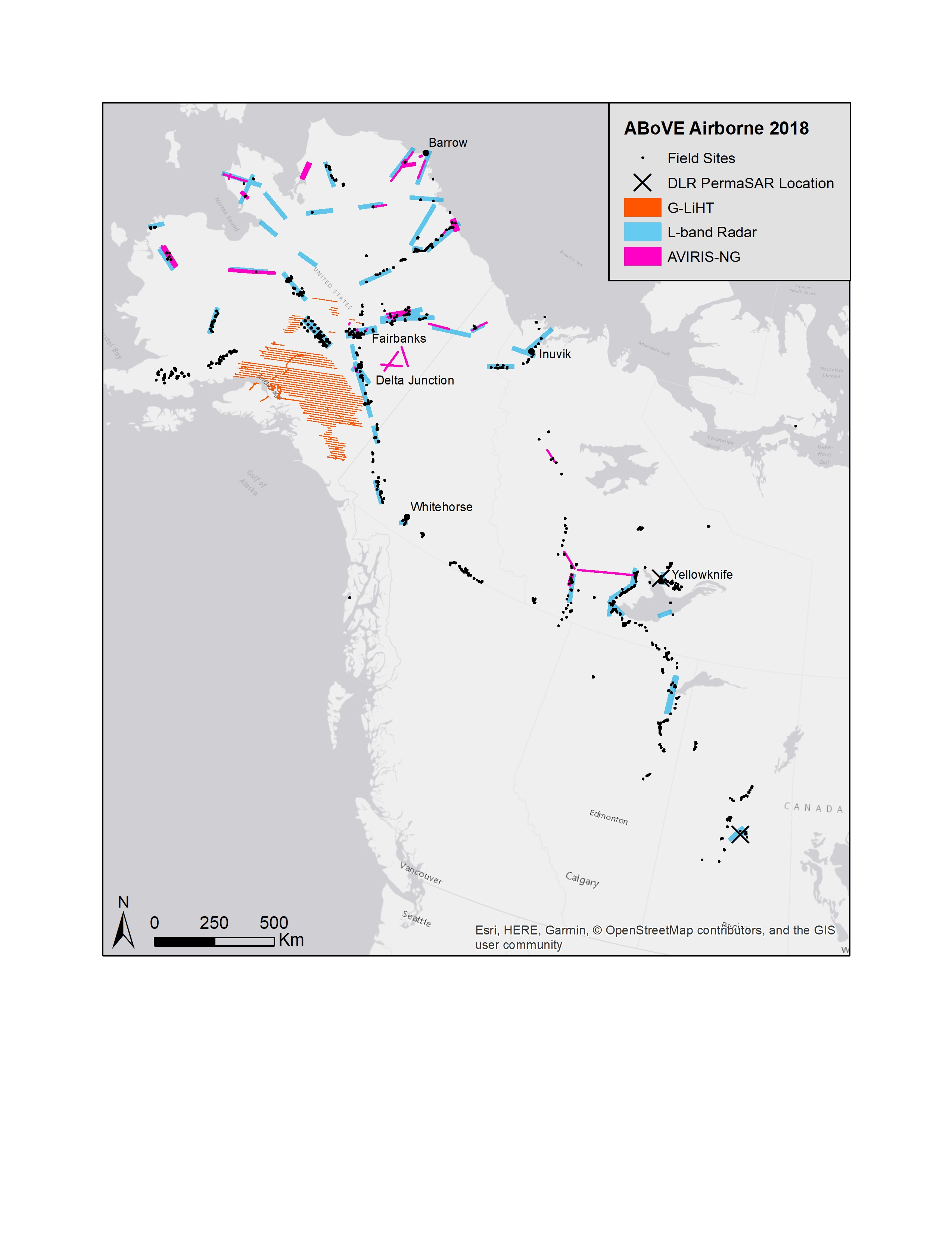
NASA conducted AVIRIS-NG flights during July 21 through 18 August, 2018. Primary mission was to obtain imagery over areas that were not imaged in 2017 due to weather conditions. Some flights were flown in "methane mode" over regions known or suspected to have high methane emissions.
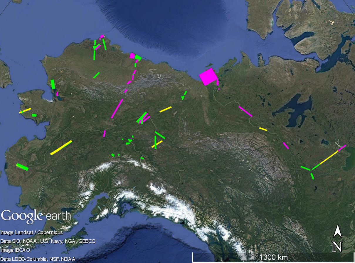
In the KMZ: GREEN = science quality data; YELLOW = partial cloud/smoke/other imperfections (parts of the line may be good); MAGENTA = unusable/unacquired lines.
NASA conducted L-Band SAR (UAVSAR) flights during 18-31 August of 2018, repeating lines flown during the 2017 campaign to establish a multi-year time series. Sites included the BERMS site in Saskatchewan, the Peace-Athabascan Delta, road-accessible sites near Yellowknife and Inuvik, and a subset of sites in Alaska and Yukon that were of greatest interest to the SAR Working Group. New flight lines were planned and executed in coordination with the German Aerospace Center (see below). The BERMS sites was flown in TomoSAR mode.
The DLR flew their F-SAR instrument over regions of the ABoVE Domain in the Northwest Territories and Saskatchewan in August 2018. DLR and ABoVE will share airborne and ground validation data from the coordinated collections at the Boreal Ecosystem Research and Monitoring Sites (BERMS) in Saskatchewan and at the Baker Creek watershed near Yellowknife, NT.
During the active flight season, the NEON project flies two Airborne Observation Platforms (AOP) to collect data across NEON field sites. See the NEON Airborne Remote Sensing webpage.
In the KMZ: GREEN = science quality data; YELLOW = partial cloud/smoke/other imperfections (parts of the line may be good); MAGENTA = unusable/unacquired lines.
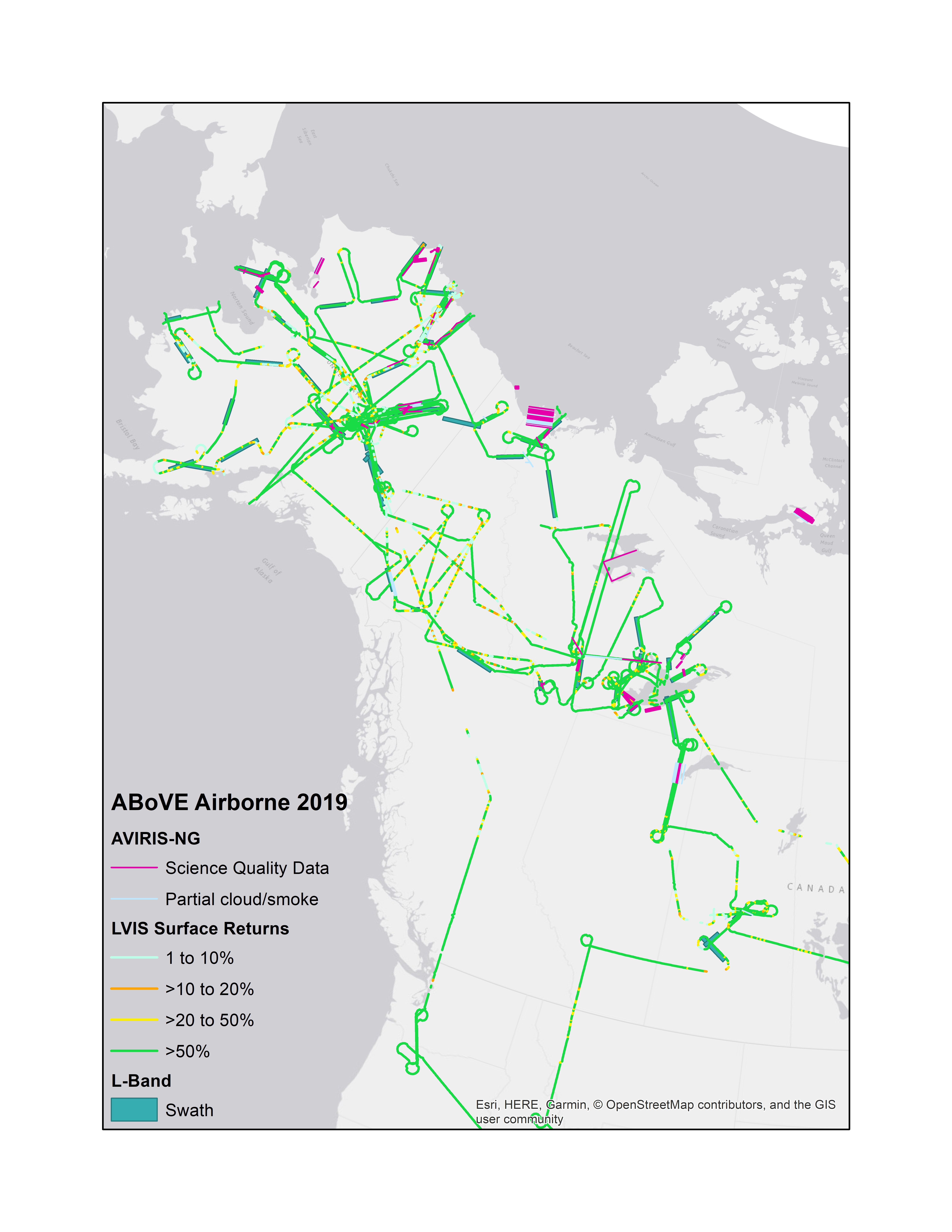
Statistics for the AVIRIS 2019 ABoVE Airborne Campaign
- Campaign Duration: 36 Days (30 June – 4 August)
- Number of Science Flight Days: 27
- Number of Sorties: 37
- Number of flight hours: 129
- # lines acquired: 193 (this number will increase given some lines were flown multiple times)
- Est km of flight lines: 15,712 km (see column U, this number will increase given some lines were flown multiple times)
- Est number of sq km mapped: 51,850 km2 (see column W, this number will increase given some lines were flown multiple times)
NASA ABoVE conducted coordinated airborne and fieldwork in 2022. L-Band SAR and AVIRIS flights were flown in Alaska and Canada during the months of July and August. Flights were planned in coordination with NASA–funded investigators, PIs of affiliated projects, and representatives of Partner Organizations.
Multiple teams executed ground observations underneath the flight paths of the aircraft and instruments.
NASA conducted L-band SAR flights on the AFRC NASA802 during 12-25 August, 2022, repeating lines flown during the 2017, 2018, and 2019 campaigns to continue the multi-year time series, and enable accurate interferometric differencing and comparisons of interannual variability in permafrost active layer thickness, thermokarst, post-fire permafrost degradation and boreal forest structure. Sites included the BERMS site in Saskatchewan, the Peace-Athabascan Delta, road-accessible sites near Yellowknife and Inuvik, and sites in Alaska and Yukon that were of greatest interest to the SAR Working Group.
Flights can be viewed and downloaded from this web map. Dates of flights are posted on the UAVSAR Calendar.
Protocol for Active Layer Thickness Surveys
Protocol for Soil Moisture Measurements
Notes on the Protocols
NASA conducted AVIRIS-NG flights during July and August 2022.
Integration & Testing (Bridgewater, VA): 28-30 June 2022
Transit to AK: 1-6 July 2022
Science Flights and Motivation:
- USFS Southwest Inventory Unit (southern half). Multi-sensor airborne data was collected with NASA Goddard's Lidar, Hyperspectral and Thermal (G-LiHT) airborne imager over Forest Inventory and Analysis (FIA) plots and transects between FIA plots in Alaska to improve regional estimates of aboveground forest biomass and terrestrial ecosystem carbon stocks.
- Carbon Cap-and-Trade Pilot Study (near Fairbanks, AK). The objectives of this pilot project are to assess the feasibility of using repeat-pass G-LiHT measurements to estimate aboveground carbon stocks with sampling error below the 20% threshold and to develop the most cost-effective carbon inventory protocol using a combination of field inventory data and advanced, multi-sensor airborne remote sensing.
- FIA Plot Cal/Val (near Anchorage, AK). G-LiHT image data will be acquired over USFS FIA training plots where field crews will be collecting traditional measurements and Terrestrial Laser Scanning (TLS) data during August 2022.
- Spruce Beetle Monitoring (near Anchorage, AK). G-LiHT image data was re-acquired over spruce beetle monitoring transects stretching from the Kenai Peninsula, in the south, to Denali National Park, in the north. These transects were last measured on the ground and with G-LiHT during 2018, during the peak of a spruce beetle outbreak, and changes in vegetation structure and spectral reflectance will be used to evaluate the long-term mortality and growth of these forests.
- Chugach National Forest and Coastal AK. USFS Geospatial Technology and Applications Center (GTAC) used G-LiHT data acquired over FIA and GTAC measured ground plots and area between plots to map forest characteristics on federally managed lands, including forest type, biomass, vegetation structure, tree and shrub cover, etc. Data will also be used to guide future inventory efforts in Coastal AK using methods developed for Interior AK.
Base of Operation and Dates:
- Kodiak, AK — 6-16 July 2022
- Aniak, AK — 16-26 July 2022
- Kodiak, AK — 26-30 July 2022
- Notional G-LiHT plans for 2022 (KML)
- To see where G-LiHT has flown in Alaska this year, click and select "View All Tracks"
This year ABoVE coordinated with CoMet 2.0 Arctic. This initiative was developed by the German Space Agency (DLR) to learn more about the distribution and temporal variation of the two most important anthropogenically-influenced greenhouse gases, carbon dioxide (CO2) and methane (CH4), in the Arctic. Aircraft-based instruments using both remote sensing and in-situ techniques carried out measurements of these trace gases and tracers related to their emissions. The results will help to better understand the global methane and carbon cycle. This mission makes use of the German research aircraft HALO. This mission was based out of Edmonton, Alberta. See this pdf for more information on CoMet 2.0 Arctic.
NEON based their AOP Payload 1 in Deadhorse Alaska, July and August 2022, to fly NEON Domain 18.
NASA GEOS-FP weather and chemistry forecast data, both in lat-lon plot and datagram form, with forecast archives remaining available for up to two weeks after they are run. The lat-lon plots include full and zoomed in views of the ABoVE domain over Alaska and western Canada.
NOAA High-Resolution Rapid Refresh (HRRR) for Alaska
FAA Weather Cameras - Interactive map with Alaska and Canadian cameras
- UAVSAR ABoVE Deployment Summary Part 1 (PDF)
- 8.17.2022 SAR report (DOCX)
- 8.13.2022 (DOCX)
- 8.12.2022 (DOCX)
- 8.10.2022 Fort McMurray + CoMET (PPTX)
- 8.10.2022 (DOCX)
- 8.07.2022 (DOCX)
- 8.06.2022 (DOCX)
- 8.04.2022 Fairbanks Area 4 (PPTX)
- 8.03.2022 Deadhorse Coastal (PPTX)
- 8.01.2022 (DOCX)
- 7.31.2022 AAC SAR supplement (DOCX)
- 7.30.2022 (DOCX)
- 7.29.2022 Fairbanks Area 3 (PPTX)
- 7.29.2022 (DOCX)
- 7.27.2022 King Salmon - Kenai (PPTX)
- 7.25.2022 (DOCX)
- 7.24.2022 Fairbanks Area 2 (PPTX)
- 7.23.2022 Fairbanks Area (PPTX)
- 7.19.2022 (DOCX)
- 7.15.2022 (DOCX)
- 7.14.2022 (DOCX)
- 7.13.2022 - Seward Peninsula - Huslia (PPTX)
- 7.12.2022 (DOCX)
- 7.11.2022 (DOCX)
- 7.10.2022 - Noatak - Kotzebue - Selawik (PPTX)
- 7.09.2022 - Deadhorse (PPTX)
- 7.09.2022 (DOCX)
- 7.06.2022 - Beaver - Coldfoot - Bettles - Grouse Creek (PPTX)
- 7.05.2022 - Toolik - Fairbanks (PPTX)
- 7.05.2022 (DOCX)
- 7.04.2022 (DOCX)
- 7.03.2022 (DOCX)
- 6.29.2022 (DOCX)
NASA ABoVE conducted coordinated airborne and fieldwork in 2023. AVIRIS flights were flown in Alaska and Canada during the months of July and August. Flights were planned in coordination with NASA-funded investigators, PIs of affiliated projects, and representatives of Partner Organizations. The L-band SAR will next be flown in 2024.
Multiple teams executed ground observations underneath the flight paths of the aircraft and instruments.
NASA conducted AVIRIS-3 flights during July and August 2023.
AVIRIS-3 Flight Summaries
The Perma-X campaign conducted flights on the AWI Polar-6 aircraft in NW Canada in July 2023. They had the super-high-resolution Modular Aerial Camera System (MACS) (sensor heads: 1x 50MP RGB, 1x 50MP NIR, 1x 1MP TIR) on board and a full-wave-form LiDAR. Their core areas of interest were repeat flights over Trail Valley Creek, Inuvik-Tuk-Highway, Yukon Coastal Plain coastline and Herschel Island, some areas in the Mackenzie Delta, and thermokarst lakes and thaw slumps (Peel Plateau) in the region. PermaX flew over areas previous flown by AVIRIS.
NEON based their AOP Payload 1 in Fairbanks Alaska, summer 2023, to fly NEON Domain 18. Visit their flight report archive.
NASA GEOS-FP weather and chemistry forecast data, both in lat-lon plot and datagram form, with forecast archives remaining available for up to two weeks after they are run. The lat-lon plots include full and zoomed in views of the ABoVE domain over Alaska and western Canada.
NASA ABoVE conducted coordinated airborne and fieldwork in 2024. L–Band SAR flights flew in Alaska and Canada in the month of August. Flights were planned in coordination with NASA–funded investigators, PIs of affiliated projects, and representatives of Partner Organizations.
Planning for the L-band campaign included coordination with multiple teams conducting ground observations underneath the flight paths of the aircraft and instruments. If you worked in the domain during the time frame of any of the flights and want to contribute your data, please email Liz Hoy.
NASA conducted L-band SAR flights on the AFRC NASA802 during 15-30 August, 2024, repeating lines flown during the 2017, 2018, 2019, and 2022 campaigns to continue the multi-year time series, and enable accurate interferometric differencing and comparisons of interannual variability in permafrost active layer thickness, thermokarst, post-fire permafrost degradation and boreal forest structure. Sites included the Peace-Athabascan Delta, road-accessible sites near Yellowknife and Inuvik, and sites in Alaska and Yukon that are of greatest interest to the SAR Working Group and the SWOT validation team. Of note for these flights is the opportunity to produce before-and-after InSAR observations of areas burned in 2022 and 2023 in both Alaska and Canada.
Flights and completed lines can be viewed and downloaded below. Dates for flights are posted on the UAVSAR Calendar. Operational updates were sent to the ABoVE Airborne Daily email list during the campaign.
Protocol for Active Layer Thickness Surveys
Protocol for Soil Moisture Measurements
Notes on the Protocols
Download 2022 L-Band Footprints KMZ
UAVSAR Flight Summaries
The G-LiHT campaign was postponed to 2025. See https://gliht.gsfc.nasa.gov/ for additional details.
NEON plans to base their AOP Payload 1 in Deadhorse Alaska, TBD, to fly NEON Domain 18. If you are interested in tracking NEON's 2024 season, sign up to receive daily flight report emails by NEON Domain or visit their flight report archive. Please note, you will only receive emails during the time period the AOP is in the Domain you have signed up to follow.
NASA GEOS-FP weather and chemistry forecast data, both in lat-lon plot and datagram form, with forecast archives remaining available for up to two weeks after they are run. The lat-lon plots include full and zoomed in views of the ABoVE domain over Alaska and western Canada.
Once archived, all ABoVE Airborne Campaign data will be available through the NASA Earthdata web portal here: https://search.earthdata.nasa.gov/search
Tutorial to access ABoVE Airborne data available here: https://daac.ornl.gov/resources/tutorials/search-above-data/
Foundational
| Instrument | Year | Data Product Download | Searching Instructions |
|---|---|---|---|
| L-Band SAR | 2017 2018 2019 2022 2024 |
UAVSAR |
|
| P-Band SAR | 2017 | UAVSAR |
|
| LVIS | 2017 2019 |
NSIDC |
|
| AVIRIS-NG | 2017 2018 2019 2022 2023 |
||
| AVIRIS-3 | 2023 | AVIRIS-3 | |
| G–LiHT | 2018 | G-LiHT |
PI Instrument
| Instrument | Year | Data Product Download | Searching Instructions |
|---|---|---|---|
| AirSWOT | 2017 | Archived at the ORNL DAAC | 4 AirSWOT datasets available. |
| CFIS | 2017 | Preliminary data available | Data archive in process at ORNL DAAC. |
| ArcticCAP | 2017 | Archived at the ORNL DAAC |
2 Arctic-CAP datasets available. |
| ASCENDS | 2017 | Available at LaRC Airborne Science Data | |
| ATom | 2017 | Available at the ORNL DAAC |
Partner Instruments
| Instrument | Availability | Data Product Download |
|---|---|---|
| NEON | Now |