Section 4.2 ABoVE Standard Projection and Reference Grid
Justification
|
Justification
The ABoVE field campaign provides the opportunity to expand and coordinate a set of focused, interdisciplinary research activities designed to further understand the causes and consequences of change in the social-ecological systems
of the Arctic and boreal regions of western North America. The campaign is developing multiple geospatial datasets. To facilitate data interoperability, a standard projection and reference grid were developed to cover
the ABoVE study domain.
The domain for the study area is over 6.3 x 10⁶ km2 as shown in the red and purple outlines in Figure 1. Thematic data products are generated from field measurements, flux towers, airborne remote sensors and satellite remote
sensing data. The datasets will considerably in resolution, format, geographic extent, projection and/or reference system. This variability in ABoVE datasets would place a considerable burden on individual researchers
as they would need to standardize the incoming datasets to support geospatial analysis, thus leading to duplicated effort across research groups utilizing these products. This duplication of effort will continue to propagate as
outcomes of scientific analysis from individual research groups will require subsequent standardization to support their further inclusion in ABoVE science projects. Implementing a standard projection and grid enables the
producers of the data to align and subdivide data products in order to ease archiving and distribution of datasets (both for long-term archiving of the data and near-term use throughout the campaign’s duration), and simplifies
data standardization for scientific analysis within ABoVE. This compatibility across multiple datasets facilitates interoperability of the datasets in scientific analysis, and is an important benefit of the standardized projection
and reference grid.
Additionally, many data products will be generated with medium to fine resolution (30m spatial resolution or less) imagery and hence would be too large to distribute to users as single files covering the entire study region.
Where the projection provides a mechanism to ensure that the products are geometrically compatible, the reference grid provides a standardized way to break the files up into units that are easy to download and manipulate by the
researchers.
The approach taken here is modeled after the MODIS standard products. Below is a list of assumptions that were used when determining the projection and grid:
- While the projection would be applicable to multiple data types, the grid would primarily be used for raster products produced over the study domain (not including circumpolar datasets).
- To provide areal calculations from the data products we need to have the data in an equal area projection.
- The products could range from fine spatial resolution (1 – 5m) to coarse spatial resolution (250m or more).
- 30m will be a central spatial resolution.
- Users of raster data can easily download files that are 300MB in size.
Standard Projection
The projection for use and archiving of geospatial data products for the ABoVE study domain is the Canada Albers Equal Area projection. This projection has been selected because it is equal area, is widely supported in geospatial software (ESRI, ENVI, gdal, etc), is commonly used for data products in this region, and has central meridian and parallels within the high northern latitude areas that are the focus of the ABoVE campaign.
Projection Specifications:
Canada_Albers_Equal_Area_Conic
WKID (EPSG): 102001 Authority: ESRI
Projection: Albers
False_Easting: 0.0
False_Northing: 0.0
Central_Meridian: -96.0
Standard_Parallel_1: 50.0
Standard_Parallel_2: 70.0
Latitude_Of_Origin: 40.0
Linear Unit: Meter (1.0)
Geographic Coordinate System: GCS_North_American_1983
Angular Unit: Degree (0.0174532925199433)
Prime Meridian: Greenwich (0.0)
Datum: North_American_1983
Spheroid: GRS_1980
Semimajor Axis: 6378137.0
Semiminor Axis: 6356752.314140356
Inverse Flattening: 298.257222101
Reference Grid
The grid is applicable mainly for raster-based products derived for the study domain (but would not apply to circumpolar datasets). The grid has been designed to cover the entire study domain, and extends to the eastern portions of North America (see Figure 1 below) to accommodate any products that are looking at continental scale processes. This grid is similar to the MODIS tiling scheme and is a nested set of grids provided at scales of 240, 30, and 5 meter spatial resolution, such that products from MODIS, Landsat, and very high spatial resolution (VHR) data would be compatible within the grid. It is easily scalable for products of 1 meter to 10 kilometers by switching from one grid resolution to another as the resolution gets coarser. The three grids (Table 1) cover the same spatial extent and nest within each other (see Reference grid nesting scheme and between grid conversion)
| Grid Name | Resolution | Grid cell (m) | # of horizontal (h) tiles |
h tiles range | # of vertical (v) tiles |
v tiles range |
|
A |
coarse |
240 |
6 |
h000 - h005 |
4 |
v000 - v003 |
|
B |
moderate |
30 |
36 |
h000 - h035 |
24 |
v000 - v023 |
|
C |
fine |
5 |
216 |
h000 - h215 |
144 |
v000 - v143 |
Table 1. Summary description of the three nested grid system for the ABoVE data products.
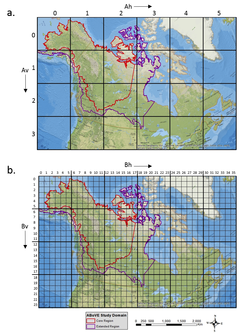
Figure 1. The ABoVE reference grid and study domain. a) The 240 m reference grid (4500 X 4500 grid cells per tile) with associated Ah and Av values and b) The 30 m reference grid (6000 X 6000 grid cells per tile) superimposed on the “A” grid.
Citation
Loboda, T.V., E.E. Hoy, and M.L. Carroll. 2017. ABoVE: Study Domain and Standard Reference Grids, Version 2. ORNL DAAC, Oak Ridge, Tennessee, USA. https://doi.org/10.3334/ORNLDAAC/1527
Gridded ABoVE datasets of the extent larger than 100X100 km2 are to be produced in this grid and projection (this is roughly a Landsat tile). Also, we recognize that at very high resolution, reprojection of original data can result in substantial spatial shifts in orientation, location, and shape of small objects; therefore, science team members are encouraged to submit their fine-scale datasets in the original projection in addition to the ABoVE grid format (if the extent of their dataset is greater or equal to 10,000 km2) or only in the original projection if it is smaller than that size.
Reference Grid Naming Convention
The reference grid naming convention is, again, modeled after the MODIS grid using horizontal (h) and vertical (v) offsets from the upper left corner to describe the tile. For example in Figure 1a (showing the large grid) the
tile in the upper left corner is referred to as “h000v000” and the tile in the lower right corner is referred to as “h005v003”. Figure 1b shows the smaller grid nested inside the larger grid.
For each of the large tiles there is a series of small tiles nested inside. The large grid is referred to as “A”, the medium grid is referred to as “B”, and the small grid is referred to as “C”.
This yields a naming convention such as:
For the A – grid:
ABoVE.water.2001001.Ah000v000.001.2014075120101.hdf
Where:
ABoVE – refers to the campaign
Water – refers to the product ID or type
2001001 – refers to the data reference date
Ah000v000 – refers to the upper left tile
in the “A” or larger grid
001 – refers to the version of the product
2014075120101 – is a production date for the product
For the B – grid:
ABoVE.water.2001001.Bh002v003.001.2014075120101.hdf
Where:
ABoVE – refers to the campaign
Water – refers to the product ID or type
2001001 – refers to the data reference date
Bh002v003 – refers to the purple tile in the “B”
or medium grid (figure 2a)
001 – refers to the version of the product
2014075120101 – is a production date for the product
For the C – grid:
ABoVE.water.2001001.Ch014v020.001.2014075120101.hdf
Where:
ABoVE – refers to the campaign
Water – refers to the product ID or type
2001001 – refers to the data reference date
Ch014v020 – refers to the green tile in
the “C” or fine grid (figure 2b)
001 – refers to the version of the product
2014075120101 – is a production date for the product
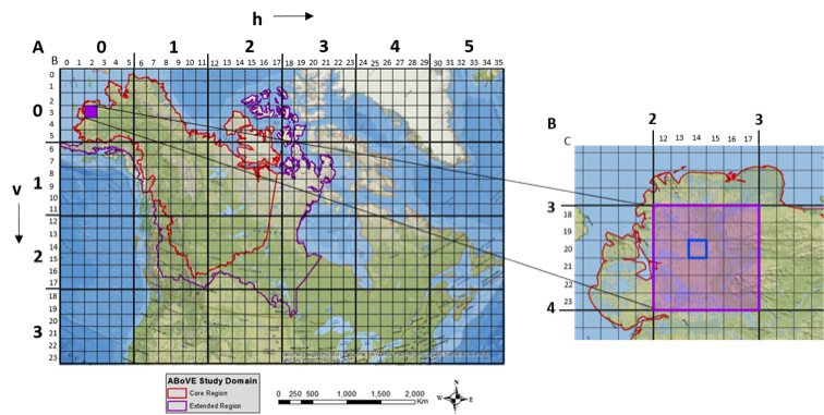
Figure 2 A) The location of sample tile Bh002v003 (in purple) within both the larger “A” grid (in bold) and the smaller “B” grid. B) the location of sample tile Ch014v020 within the larger two grids is shown.
To simplify downstream processing it is recommended that all products use three digit identifiers for all grid tile identifiers (i.e. Ch014v020 instead of h14v20) to facilitate scripting in analyses later on.
Reference grid nesting scheme and between grid conversion
The nesting scheme provides a standardized and straightforward tiling pattern where each of the larger tiles is composed from 6 X 6 (36) smaller tiles of the smaller grid system. For example, a single tile for the coarse resolution
A-grid is contains 6 X 6 (36) tiles of B-grid. Similarly, each single tile of B-grid contains 6 X 6 (36) tiles of C-grid. Simple calculations can be used to translate between resolutions. For example:
To find the location of a given the C-grid tile Ch036v012 within B-grid, the horizontal (h036) and vertical (v012) components of the tile numbering should be divided by 6:
floor(36 / 6) = 6 and floor(12/6 = 2) (“floor” is a math function that truncates floating point values to integers without rounding)
Hence Ch036v012 is found in Bh006v002. The position of a C-grid tile within the A-grid can be determined in a similar way by dividing h and v components by 36:
floor(36/36) = 1 and floor(12/36) = 0
Hence Ch036v012 is in Ah001v000. Translating from the B-grid to the A-grid is the same as translating from C-grid to B-grid, simply divide h and v by 6.
Given Bh010v008:
floor(10/6) = 1 and floor(8/6) =1
Hence Bh010v008 is in Ah001v001. This simple translation method can facilitate analysis that requires using multiple products at varying spatial resolutions. A user can also simply query the associated shapefiles
using GIS software to find where a finer resolution tile nests within the coarser resolution grids. A shapefile for each of the three grids is available from the Oak Ridge National Laboratory DAAC or from the ABoVE website.
For further information or questions regarding the projection or grid please contact support@cce.nasa.gov.