Aug 16— AirSWOT — ERMS-Saskatoon Joint Ground-Air Campaign
-
Today the AirSWOT team executed a Joint Ground-Air Campaign in the BERMS-Saskatoon area. The preliminary summary characterizes the conditions during the period of the airborne acquisitions. AVIRIS also flew the Saskatoon/BERMS area lines 2x.
Clouds moved through the area during the AirSWOT overflights, so a second data acquisition is planned for Thursday 8/17.
Attached Files
2017-08-16 - AirSWOT (Ka-band SAR) - BERMS-Saskatoon Joint Ground-Air Campaign - 2017 AAC Science Summary
Aug 14— P-band SAR — SW Alaska-YK Delta
-
Please find a summary for the 14 Aug P-band SAR flight to Southwest Alaska (& the SWAN network) and the Yukon-Kuskokwim Delta. See chart #8 for possible evidence of post-fire polygonalization of Bering tundra where the Schaefer, Frost and Natali groups have field measurement sites.
Attached Files
2017-08-14 - P-band SAR - SW Alaska-YK Delta - 2017 AAC Daily Science Summary
July 20— AVIRIS — YK Delta
-
Attached please find the preliminary science summary for AVIRIS/N53W flight to the Yukon-Kuskokwim Delta on 20 July.
N53W was scheduled to be delivered for upgrades to its navigation system on 20 July, but the team took advantage of clearing conditions in the YK Delta to refly lines which had been obscured by fog on the 7 July flight. High quality images were obtained for most coastal lines as well as the interior.
The plane was then taken to Kenai for the following week during which there were no science operations.
Attached Files
2017-07-20 - AVIRIS - YK Delta - Kenai - 2017 AAC Daily Science Summary
July 19 — AVIRIS — Old Crow, Whitehorse
-
Attached please find the preliminary science summary for AVIRIS/N53W flight to Old Crow & Whitehorse on 19 July.
Conditions in the Yukon Territory were very good, so the team attempted to obtain smoke-free images over the Old Crow Flats in the morning, then made an afternoon sortie through SE Alaska to the Kluane Lake — Whitehorse region.
Excellent images obtained over the lakes monitored by K Turner in Old Crow Flats and the alpine Valley near Kluane Lake that has been monitored from Hyperion/EO-1
Attached Files
2017-07-19 - AVIRIS - Old Crow; Whitehorse - 2017 AAC Daily Science Summary
July 18 — AVIRIS — Interior Alaska
-
Attached please find the preliminary science summary for AVIRIS/N53W flight to Interior on 18 July.
Lines flown over Delta Junction NEON box, Denali National Park monitoring sites, Fairbanks and up the Dalton Highway.
Attached Files
2017-07-18 - AVIRIS - Interior Alaska - 2017 AAC Daily Science Summary
July 14 — AVIRIS — Noatak — Barrow
-
Attached please find the preliminary science summary for AVIRIS/N53W flight to Noatak - Barrow on 14 July.
The team took advantage of a sudden clearing over Barrow to divert north and reacquire imagery over the Barrow area to track vegetation evolution during the rapid change period approaching peak productivity, and obtain cloud-free images over scenes that had been compromised by clouds on 9 July.
Very high quality images obtained.
Attached Files
2017-07-14 - AVIRIS - Noatak - Barrow - 2017 AAC Daily Science Summary
July 13 — AVIRIS — Deadhorse — Toolik Lake
-
Attached please find the preliminary science summary for AVIRIS/N53W flight to Deadhorse & Toolik Lake on 13 July.
High quality imagery was acquired over: ·Toolik Lake LTER (NSF)
·Toolik Lake NEON box (NSF)
·Dalton Highway sites – many ABoVE investigations
·Euskirchen flux towers @ Imnavait Creek
Dead horse energy infrastructure (Miller & Sweeney investigations)
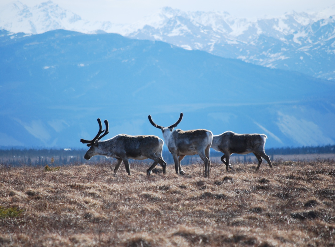
·Anaktuvuk River fire scar and mobile flux towers (Iwahana, Rocha)
Some interference from patchy clouds and smoke
Attached Files
2017-07-13 - AVIRIS - Deadhorse - Toolik Lake - 2017 AAC Daily Science Summary
July 9 — AVIRIS — Barrow — North Slope
-
Attached please find the preliminary science summary for AVIRIS/N53W flight to the Barrow - Atqasuk area on 9 July.
The team took advantage of rare clear sky conditions in and around Barrow to acquire coordinated data with the LVIS, CFIS and ArctiC-C teams. The imagery acquired characterized the unique vegetation and lake structures of the Arctic Coastal Plain in support of the Huemmrich, Drewry, Sweeney and Miller ABoVE investigations, as well as covering the NEON and NGEE-Arctic sites at Barrow.
Attached Files
2017-07-09 - AVIRIS - Barrow - North Slope - 2017 AAC Daily Science Summary
July 7 — AVIRIS — YK Delta
-
Attached please find the preliminary science summary for AVIRIS/N53W flight to the YK Delta on 7 July.
This flight imaged ground sites for the Frost, Schaefer, and Natali ABoVE projects. Intermittent coastal clouds interfered with some of the data collection lines, but many of the interior YK Delta images are cloud-free and spectacular.
Attached Files
2017-07-07 - AVIRIS - YK Delta - 2017 AAC Daily Science Summary
July 6 — AVIRIS — SE Alaska
-
Attached please find the preliminary science summary for AVIRIS/N53W flight to SE Alaska on 6 July.
Flights over important ground sites in Interior Alaska were imaged:
·Delta Junction NEON site (NSF),
·Bonanza Creek LTER (NSF),
·Denali National Park long-term sites (NPS),
·CRREL fire and permafrost sites (USGS),
·Caribou-Poker Creek NEON site (NSF)
Attached Files
2017-07-06 - AVIRIS - SE Alaska - 2017 AAC Daily Science Summary
July 20— AirSWOT — Fort Yukon joint ground-air survey
-
Attached please find a preliminary science summary of the AirSWOT joint ground-air survey flown over Fort Yukon on Thurs 20 July. Unfortunately, the forecsat for clear skies disintegrated and there were overcast conditions and precipitation during the overflight. The flights were executed nonetheless since this was the only opportunity for the ground team to be in the field near Fort Yukon since they were headed to the North Slope/Sag River area to support another joint ground-air survey on Fri 21 July.
The report will be updated once quick-look data products become available.
Attached Files
2017-07-20 - AirSWOT (Ka-band SAR) - Fort Yukon joint ground-air survey - 2017 AAC Science Summary
July 19— AirSWOT — Sag River survey
-
Attached please find a preliminary science summary for the 19 July flight of AirSWOT / N801NA to the North Slope for a joint ground-air survey of the Sag River. A revised report will be distributed when quick look products are available.
Attached Files
2017-07-19 - AirSWOT (Ka-band SAR) - Sag River - 2017 AAC Science Summary
July 19— CFIS — Fort Smith NT - Saskatoon SK
-
Attached please find the ABoVE Airborne Campaign summary for the CFIS / N331AR flight form Fort Smith NT to Saskatoon SK on 19 July. The report will be updated once quick-look products are available.
Attached Files
2017-07-19 - CFIS - Fort Smith - Saskatoon - 2017 AAC Daily Science Summary
July 18— CFIS — Scotty Creek flux towers
-
Attached please find a preliminary science summary for the CFIS team flight over the Scotty Creek flux towers. The team made both morning and afternoon data acquisitions under mostly cloud-free conditions.
The report will be updated when quick-look data products become available.
Attached Files
2017-07-18 - CFIS - Scotty Creek - Fort Smith - 2017 AAC Daily Science Summary
July 17—LVIS — BERMS/BOREAS area
-
Attached please find a preliminary science summary for the 17 July LVIS flight over the BERMS/BOREAS area. The summary will be updated when quick-look products become available.
Attached Files
2017-07-17 - LVIS - BERMS-BOREAS area - 2017 AAC Daily Science Summary
July 17—AirSWOT / Ka-SPAR
-
Inuvik — Fairbanks flight summary. Will update when quick-look data products are ready
Attached Files
2017-07-17 - AirSWOT (Ka-band SAR) - Old Crow-Fort Yukon - 2017 AAC Science Summary
June 21—UAVSAR — North Slope
-
Attached please find the 2017 AAC daily report for UAVSAR Campaign #1, Flight #8 covering the North Slope and Yukon Flats.
Attached Files
2017-06-21 - UAVSAR (L-band SAR) - North Slope - 2017 AAC Daily Science Summary
June 20—UAVSAR — Mackenzie Valley
-
Attached please find the 2017 AAC daily report for UAVSAR Campaign #1, Flight #7 covering the Mackenzie Valley, Mackenzie Delta, and Old Crow YT.
Attached Files
2017-06-20 - UAVSAR (L-band SAR) - Mackenzie Valley - 2017 AAC Science Summary
June 19—UAVSAR — Seward Peninsula
-
June 18 was a hard down day.
Attached please find the 2017 AAC daily report for UAVSAR Campaign #1, Flight #5 covering the Seward Peninsula, Noatak, and some sites in the southern North Slope.
Attached Files
2017-06-19 - UAVSAR (L-band SAR) - Seward Peninsula - 2017 AAC Science Summary
June 17—UAVSAR — YK Delta
-
Attached please find the 2017 AAC daily report for UAVSAR Campaign #1, Flight #5 covering the Yukon-Kuskokwim Delta.
These lines include a couple over tundra burn regions that multiple research teams are using to study the impact of burns on permafrost state and condition, carbon fluxes, and wildlife.
Attached Files
2017-06-17 - UAVSAR (L-band SAR) - YK Delta - 2017 AAC Daily Science Summary
June 16—UAVSAR — Southwest Alaska
-
Attached please find the 2017 AAC daily report for UAVSAR Campaign #1, Flight #4 covering Southwest Alaska.
These lines include many of the SWAN sites that provide valuable soil moisture and vegetation ground truth.
Attached Files
2017-06-16 - UAVSAR (L-band SAR) - SW Alaska - 2017 AAC Daily Science Summary
June 15—UAVSAR — Yellowknife-Fairbanks Transit
-
Attached please find the 2017 AAC daily report for UAVSAR Campaign #1, Flight #3 transit from Yellowknife-Fairbanks.
The team recorded an outstanding image of the Kaskawulsh Glacier melt drainage into Kluane Lake. This should provide additional insights into the abrupt, rapid “River Piracy” in 2016 reported by Shugar et al.
Attached Files
2017-06-15 - UAVSAR (L-band SAR) - Yellowknife-Fairbanks Transit - 2017 AAC Daily Science Summary
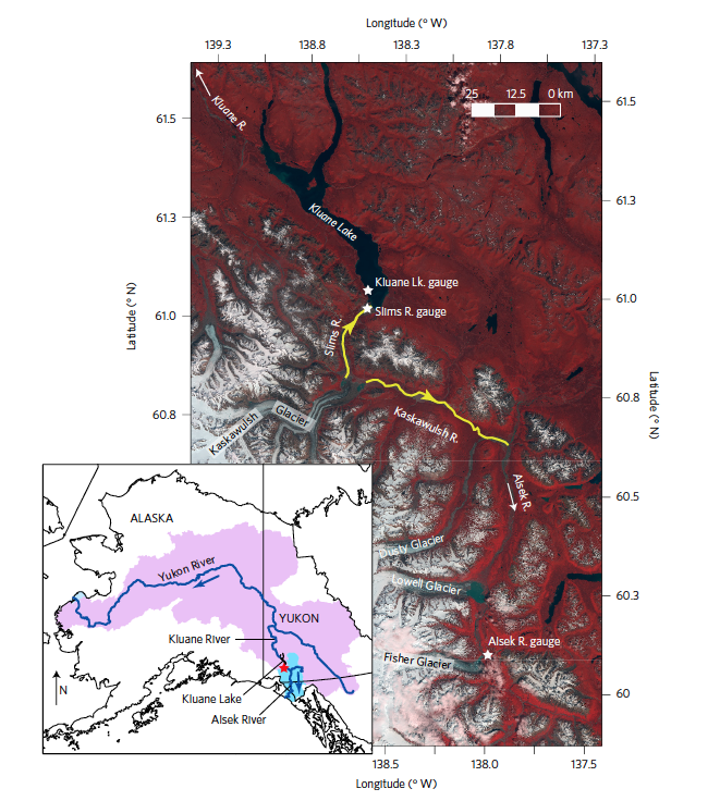
ngeo (2017) - Shugar - River piracy and drainage basin reorganization led by climate-driven glacier retreat - Kluane Lake
June 14—UAVSAR — Great Slave Lake Region
-
Attached please find the 2017 AAC daily report for UAVSAR Campaign #1, Flight #2 around the Great Slave Lake region.
Attached Files
2017-06-14 - UAVSAR (L-band SAR) - Great Slave Lake Region - 2017 AAC Daily Science Summary
June 13—UAVSAR — Palmdale CA — Yellowknife NT
-
Attached please find the 2017 AAC daily report for UAVSAR Campaign #1, Flight #1 from Palmdale to Yellowknife, sampling over Fort McMurray, the Peace-Athabasca Delta, the Slave River watershed and the Slave River Delta.
Attached Files
2017-06-13 - UAVSAR (L-band SAR) - Palmdale-Yellowknife transit - 2017 AAC Daily Science Summary.pptx
June 9—Mooney (ATM-C)
-
Attached please find the 2017 AAC daily report for ATM-C Campaign #2, Flight #4 from Nome to the North Slope and return to Fairbanks.
Excellent distinction between the C dynamics of the North Slope and the more advanced growing season dynamics south of the Brooks Range.
Attached Files
2017-06-09 - ATM-C Nome - North Slope - Fairbanks - 2017 AAC Daily Science Summary.pptx
June 7—Mooney (ATM-C)
-
Attached please find the 2017 AAC daily report for ATM-C Campaign #2, Flight #2: Inuvik – Old Crow – Fort Yukon – Fairbanks on Wednesday 7 June.
Very interesting contrasts between the C dynamics of the tundra (Inuvik, Old Crow) and boreal forest (Fort Yukon, Fairbanks) ecosystems clearly seen again in this flight.
Plan for Thurs 8 June is Fairbanks – Bethel – Nome
Attached Files
2017-06-07 - ATM-C Inuvik - Fairbanks - 2017 AAC Daily Science Summary.pptx
June 6—Mooney (ATM-C)
-
Attached please find the 2017 AAC daily report for ATM-C Campaign #2, Flight #1 from Yellowknife – Daring Lake – Yellowknife – Inuvik.
Very interesting contrasts between the C dynamics of the tundra (Inuvik, Daring Lake) and boreal forest (Fort Simpson, Norman Wells, Yellowknife) ecosystems.
Attached Files
2017-06-06 - ATM-C Yellowknife-Daring Lake - 2017 AAC Daily Science Summary.pptx
June 6—UAVSAR P-band (AirMOSS)
-
Attached please find the 2017 AAC daily report for AirMoss Campaign #1, Flight #8 from Fairbanks to the North Slope.
A "target-rich environment" with coverage of flux towers, the Barrow research area, the Dalton Highway, and the Anaktuvuk River fire scar.
Attached Files
2017-06-06 - AirMOSS (P-band SAR) - North Slope - 2017 AAC Daily Science Summary.pptx
May 31—UAVSAR P-band (AirMOSS)
-
Attached please find the 2017 AAC daily report for AirMOSS flight #6 (Flight Plan 1116 v02) covering the Seward Peninsula, Noatak, southern North Slope, and Yukon Flats NWR.
The crew are all safe after a lightning strike to the plane at the end of the flight; however, further acquisitions are on hold until the plane can be inspected and any necessary repairs implemented.
Attached Files
2017-05-29 - AirMOSS (P-band SAR) - Seward Peninsula - 2017 AAC Daily Report - v2.pptx
May 29—UAVSAR P-band (AirMOSS)
-
Attached please find the 2017 AAC daily report for AirMOSS flight #5 (Flight Plan 1114) covering the YK Delta and Innoko NWRs. Extra fuel and flight time allowed us to pick up 4 lines from Flight plan 1116 as well.
Good flying conditions and radar operation have enabled us to accelerate a number of planned acquisitions. We will continue to adjust flight plans with this strategy as the situation allows.
Attached Files
2017-05-27 - AirMOSS (P-band SAR) - YK Delta - 2017 AAC Daily Report
May 27—UAVSAR P-band (AirMOSS)
-
Attached please find the 2017 AAC daily report for AirMOSS flight #5 (Flight Plan 1114) covering the YK Delta and Innoko NWRs. Extra fuel and flight time allowed us to pick up 4 lines from Flight plan 1116 as well.
Good flying conditions and radar operation have enabled us to accelerate a number of planned acquisitions. We will continue to adjust flight plans with this strategy as the situation allows.
Attached Files
2017-05-27 - AirMOSS (P-band SAR) - YK Delta - 2017 AAC Daily Report
May 25—UAVSAR P-band (AirMOSS)
-
Attached please find the 2017 AAC daily report for AirMOSS flight #3 – a transit from Yellowknife NT to Fairbanks AK. Key acquisitions occurred over the Slave River Delta (Fort Resolution), Scotty Creek, Fort Liard, Kluane Lake, and Delta Junction.
Fuel and time pressures forced the descope of 2 lines over Kluane Lake, but these will be acquired with L-band radar and the optical sensors later in the campaign.
Attached Files
2017-05-25 - AirMOSS (P-band SAR) - Yellowknife-Fairbanks - 2017 AAC Daily Report.pptx
May 1—Mooney (ATM-C)
-
On Monday 1 May the AMT-C team executed a marathon 1400 nautical mile excursion from Nome across the North Slope to Fairbanks. Conditions across the North Slope were still frigid, but areas south of the Brooks Range showed significant signs of thaw. Attached please find the summary of that flight.
Thanks to Colm and Justin for the photos and to Kathryn and Sonja for data analysis.
Attached Files
2017-05-01 - Atmospheric C - Nome-North Slope-Fairbanks - 2017 AAC Daily Report
Apr 30—Mooney (ATM-C)
-
The ATM–C team flew a 2–leg sortie from Fairbanks – Bethel – Nome on Sunday 30 April. Interior Alaska showed regions of mixed snow and exposed land, with corresponding enhancements in the near surface CO2 and CH4 signals. Western Alaska still seemed in the grip of late winter, although there are the first hints of spring in the CO2 and CH4 data.
Thanks to Colm and Justin for the photos and a good flight.
Attached Files
2017-04-30 - Atmospheric C - Fairbanks-Bethel-Nome - 2017 AAC Daily Report.pptx
Apr 29 —Mooney (ATM-C)
-
Saturday 29 April saw the Atmospheric Carbon flights continue from Inuvik to Fairbanks. The flight was originally planned to go to Deadhorse, but conditions were superior for follow-on flights in Central Alaska, so the decision was made to go to Fairbanks instead. This allowed for a Sunday 30 April flight to Nome and the Seward Peninsula.
Conditions from Inuvik to Old Crow to Fort Yukon dominated by frozen lakes and snow cover; however, the vertical profiles in all locations show clear indications of elevated near surface CO2 and CH4 concentrations. This suggests that the spring thaw is under way.
Thanks to Colm Sweeney, Steve Conley, Justin Pifer and the ATM–C team for photos, data quick-looks, etc.
Attached Files
2017-04-29 - Atmospheric C - Inuvik-Fairbanks - 2017 AAC Daily Report.pptx
Apr 28 & 29Mooney (ATM-C)
-
The 2017 ABoVE Airborne Campaign continues with flights by the Atmospheric Carbon measurements team
- Thursday 4/28 from Yellowknife to Daring Lake and back
- Friday 4/29 from Yellowknife to Inuvik
There are clear signs of regional scale spring thaw in the vertical profile data – enhanced levels of CO2 and CH4 above background, although the enhancements near the surface are small suggesting that much of the signal is coming from outside the ABoVE domain.
Attached Files
2017-04-28 - Mooney Yellowknife-Inuvik - 2017 AAC Daily Report.pptx
2017-04-29 - Atmospheric C - Inuvik-Fairbanks - 2017 AAC Daily Report.pptx
Apr 26Mooney (ATM-C)
-
Attached please find a brief summary of the kick off of the ABoVE 2017 Airborne Campaign. The Mooney/Atmospheric CO2/CH4/CO project led by Colm Sweeney and Steve Conley took advantage of the weather and transited all the way from Boulder to Yellowknife, collecting data along the way (see attached).
- Yellowknife – Daring Lake – Yellowknife
- Vertical Profile over Daring Lake flux tower
- Yellowknife – Inuvik
- Vertical profiles over Fort Simpson, Wrigley/Smith Creek flux tower, Norman Wells, Inuvik
- Inuvik – Fort Yukon – Deadhorse
- Vertical profiles over Old Crow, Fort Yukon, Toolik Lake, Deadhorse
The Mooney is currently heading toward Daring Lake for an out-and-back flight from Yellowknife. You can follow its progress at https://airbornescience.nasa.gov/tracker/#!/map?callsign=N617DH&mapid=hybrid&zoom=4&lat=65.2674&lng=-112.0218&n0q=
Looking ahead (all plans weather dependent)
IN PROGRESS – Thursday 27 April 2017 (DOY 118):
Friday 28 April 2017 (DOY 119):
Saturday 29 April 2017 (DOY 120):
Attached Files
2017-04-26 - Mooney Transit to Yellowknife - 2017 AAC Daily Report.pptx