Section 1.5 Spatial Hierarchy
The spatial hierarchy of the ABoVE experimental design is comprised of the Study Domain (covering 6.4 million square kilometers), Core and Extended Regions, Research Areas, and Investigator Sites (Figure 3). The Study Domain includes most of northwestern North America north and east of the coastal mountain ranges and west of Hudson Bay. The study domain encompasses the variability in the key land surface features that are both unique to arctic and boreal ecosystems in North America as well as being representative of the larger northern high latitude region. The Core Region of the study domain captures the regional-scale variations in surface and atmospheric conditions necessary to address the science questions and objectives. It includes landscapes and ecoregions that are rapidly changing in complex ways, as well as others that are not – a combination that allows for studies on both vulnerability and resilience. The Study Domain includes an Extended Region outside of the Core Region whic h allows for studies focused on a subset of important changes that are not occurring in the Core Region (for example, insect outbreaks and forest dieback in the southern boreal forest). The Extended Region includes areas where research focuses on environmental conditions that are considered to be antecedent to those in the Core Region. Studies conducted in the Extended Region also provide opportunities for collaboration with existing or planned research sponsored by partners, like Polar Knowledge Canada. To build partnerships that take advantage of existing infrastructure and logistical support and to provide the variations and gradients in important surface characteristic required to address the science questions and objectives, most current ABoVE investigations are taking place in clustered research areas within the core domain.
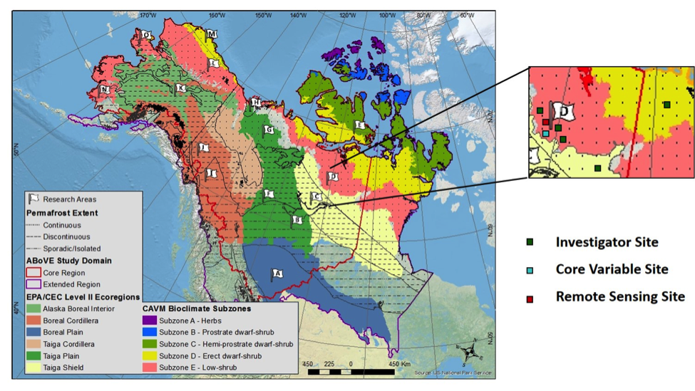
Figure 3. Spatial hierarchy for ABoVE. Research Areas (marked with flags) for ABoVE are based on the intersection of key ecoregions/tundra vegetation subzones and permafrost zones as well as the presences of different disturbance regimes. The displayed locations of Investigator, Core Variable, and Remote Sensing Sites are for illustration purposes only, where the actual locations are based on the ABoVE Working Group activities.